Racehorse Creek Chuckanut Fossil Fields Hunting Guide
Image: Whatcom Watch
Racehorse Creek in eastern Whatcom County exposes the Early Eocene Chuckanut Formation, a coastal-plain succession of sandstone, mudstone, and coal famous for fossil palm fronds, tree-fern frond compressions, and the world's only authenticated tridactyl footprint of the giant flightless bird *Gastornis*. The 2009 Racehorse Creek landslide, on WA DNR land, exposed enormous fresh blocks of fossiliferous rock. Plant fossil collecting is permitted on DNR land; vertebrate fossils (including the trackways) are protected.
Racehorse Creek runs off the southwest flank of the Twin Sisters Range in eastern Whatcom County, northwest Washington, about 25 miles east of Bellingham. The creek and its surrounding ridges cut through the Early Eocene Chuckanut Formation, the thick coastal-plain succession of sandstone, mudstone, conglomerate, and coal that crops out across the western Cascades foothills from the Canadian border south to the Skagit River. The Racehorse Creek area became a paleontological destination in January 2009, when a substantial landslide on Washington DNR-managed land dropped large fresh blocks of Chuckanut Formation rock onto the creek and surrounding slopes. In the spring of 2009, WWU geologist George Mustoe and amateur paleontologist Keith Kemplin discovered the world's only authenticated tridactyl footprint of Gastornis (formerly Diatryma), a giant flightless bird of the early Eocene, in the landslide rubble. Subsequent work has documented roughly 20 tridactyl Gastornis footprints, an assortment of smaller bird tracks, reptile (crocodile and turtle) trackways, and abundant plant fossils including large palm fronds (Sabalites) and tree-fern frond compressions (Cyathea pinnata).
Racehorse Creek sits on Washington State DNR-managed land. Per the WA DNR Rockhounding policy, collecting plant fossils is permitted; vertebrate fossils (including all of the trackways) are protected and require a scientific permit. Most of the documented vertebrate trackway material has been recovered and is curated at the WWU Geology Museum in Bellingham and at the Burke Museum in Seattle.
This guide covers the location, the geology, the plant fossils visitors can legally collect, and the trackway record that they may observe but not remove.
Location and Directions
Racehorse Creek lies in eastern Whatcom County, between Kendall and Mount Baker, along the South Fork Nooksack River drainage. From Bellingham, take WA-542 (Mount Baker Highway) east through Deming to the unincorporated community of Kendall, then turn off onto local roads into the Racehorse Creek drainage. The Washington Trails Association trip-report archive documents one well-used informal trail to the landslide fossil fields from a small pull-off on the local road system; conditions, parking, and the trail itself are unmaintained and vary by season.
Practical notes
Bring sturdy footwear for talus and brush, gloves, a small hammer and chisel (the landslide blocks are large; you split float on the slope, not the bedrock itself), water, and an offline map. There are no facilities. Cell service is intermittent. Best fossil-collecting season is dry summer through autumn. Avoid wet weather; the slope is unstable and steep in places. The WA DNR Rockhounding page is the primary authority on what may be collected here and where; check it before each visit because the agency updates the closure/collection-management status of specific DNR properties from time to time.
What Fossils You'll Find
The Chuckanut Formation is Early Eocene, deposited approximately 55 to 50 million years ago in a low-relief river-and-floodplain system that drained from rising highlands to the east into a shallow coastal embayment to the west. The depositional environment was a warm, wet subtropical to tropical lowland with broad rivers and swamps — climatically similar to the modern Gulf Coast — and the fauna and flora preserve that picture in detail.
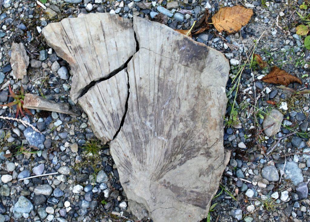
Plant fossils — these you may legally collect on DNR land. The most striking finds are large palm fronds preserved as compressed impressions in fine-grained sandstone. The genus Sabalites is the most common identification; complete fronds 30 to 60 cm across are not unusual on well-split slabs. Tree-fern fronds of Cyathea pinnata are also abundant. Hardwood leaves include sycamore-like Macginitiea, alder-related forms, beech-related forms, and several other broadleaf taxa. Compressed bark, twigs, and coalified plant debris are pervasive in the mudstones. The plants record a frost-free, perhumid subtropical lowland forest.
Trackways — protected, observe only. The 2009 landslide and subsequent surveys produced roughly 20 tridactyl footprints attributed to Gastornis (the giant flightless bird formerly known as Diatryma). Individual footprints measure approximately 25 by 27.5 cm; the trackway is the only authenticated Gastornis footprint record anywhere in the world. The same blocks preserve numerous small wading-bird tracks (heron-like, shorebird-like, and goose-related forms), turtle tracks, crocodilian tracks, and tridactyl tracks attributed to small mammals. All of these are vertebrate fossils under Washington law and may not be collected without a scientific permit; most documented material has been recovered to museum collections under permit by Mustoe and colleagues. The bedrock and the larger landslide blocks bear additional trackways that have been mapped but not removed.
"Collecting plant fossils is permitted, but it is illegal to take any vertebrate fossils from the site." Northwest Geology Field Trips guide, summarizing the WA DNR collecting rules at Racehorse Creek
Geologic History
During the Early Eocene the modern Pacific Northwest lay near 50° North latitude in a globally hot greenhouse climate. The proto-Cascade mountain front had not yet risen; the foothills of the modern North Cascades were a low coastal plain extending east from a shallow embayment of the Pacific. Rivers draining from the rising eastern highlands of the future Rocky Mountain front delivered sand, mud, and plant debris west across this plain, building thick fluvial and floodplain deposits that became the Chuckanut Formation. The formation is one of the thickest non-marine Eocene successions in North America, locally exceeding 6,000 metres in cumulative thickness.
After Chuckanut deposition the entire succession was tilted, folded, and partly faulted during later Cascade tectonism. Modern erosion has cut through the soft sedimentary rock to expose Chuckanut beds along the western Cascades foothills, with the best fossil exposures concentrated in Whatcom County. The 2009 Racehorse Creek landslide was a particularly productive natural exposure: a substantial slope failure produced fresh blocks of fossiliferous bedrock at the surface, making formerly inaccessible material recoverable.
How Racehorse Creek became a fossil site
The Chuckanut Formation has been collected since the late 19th century; F. H. Knowlton studied the early flora in the 1900s. Modern detailed work on the Racehorse Creek site began with the January 2009 landslide. WWU geologist George Mustoe and amateur collector Keith Kemplin recognised the Gastornis track in spring 2009, and Mustoe's 2012 Palaeontology paper formally described it as the world's first authenticated Gastornis footprint. WWU and Burke Museum collecting has continued. The Washington Trails Association documents the area as a hike-in destination for amateur paleontology.
Collecting Rules & Regulations
Is Fossil Collecting Allowed?
Plant fossils: yes, on WA DNR-managed land, in accordance with the WA DNR Rockhounding policy. Vertebrate fossils, including all trackway material: no — protected, requires a scientific permit.
Key Points:
- Collect plant fossils only. Vertebrate fossils (trackways, bones, teeth) require a WA DNR scientific permit.
- The 2009 landslide blocks are the standard source — work on slope talus, not the in-place bedrock face.
- Hand tools only — small hammer, chisel, splitting wedge. No power equipment.
- The slope is unstable and steep. Do not work alone; do not approach during wet weather.
- Report any significant vertebrate finds to the WWU Geology Museum or the Burke Museum.
- Check the WA DNR Rockhounding page before visiting; site closure status can change.
Sources
- Northwest Geology Field Trips: The Racehorse Landslide Fossil Fields
- Mustoe 2012, Palaeontology: Giant Eocene bird footprints from northwest Washington, USA
- Washington Trails Association: Racehorse Landslide Fossil Fields trip report
- WA DNR Washington Geological Survey: Rockhounding
- Burke Museum: Cruisin' the Fossil Freeway — Washington fossils
Nearby sites
 Chuckanut Drive & Larrabee State Park Fossil Hunting GuideFossil palm fronds (Sabalites), Fossil leaves
 Alki Beach Blakeley Formation Fossil Hunting GuideMarine mollusks, Crab concretions
 Fort Ward Park (Blakeley Formation) Fossil Hunting GuideMarine mollusks, Crab concretions
 Stonerose Interpretive Center Fossil Hunting GuideFossil Leaves, Insects