Fort Ward Park (Blakeley Formation) Fossil Hunting Guide
Image: Leah Applewhite
Fort Ward Park on the south end of Bainbridge Island is the legal public window into the Blakeley Formation type-section region. The Blakeley Formation, a 5,000-foot-thick late Oligocene to early Miocene marine succession, underlies the south end of the island from the privately owned Restoration Point bluffs west to Fort Ward and the western shoreline. Marine mollusks, crab-bearing concretions, and trace fossils show in shoreline ledges at low tide. Bainbridge Island Metro Parks administer the park as viewing-only.
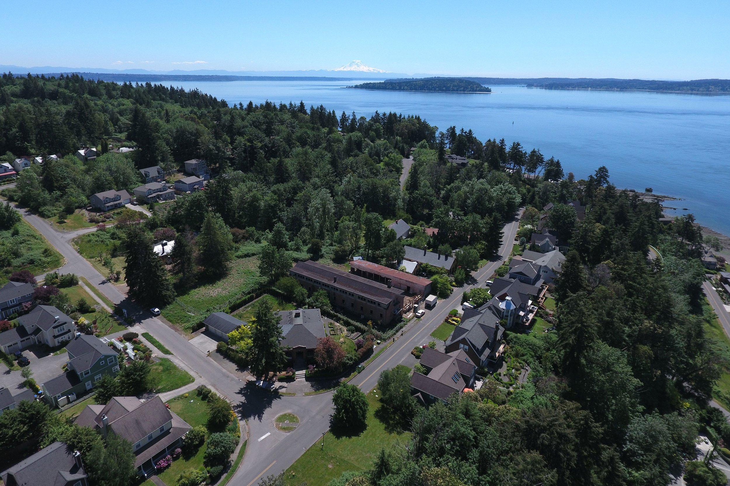
Fort Ward Park is a 137-acre Bainbridge Island Metro Park on the southern shoreline of Bainbridge Island in Kitsap County, Washington, immediately on Rich Passage across from Bremerton. The park preserves the relict structures of the World War I-era Fort Ward coastal artillery installation along a 4,300-foot stretch of saltwater shoreline. It also provides the only substantial public-land access to the Blakeley Formation in the immediate region of its named type section.
The Blakeley Formation is a roughly 5,000-foot-thick marine succession of medium-grained sandstone interbedded with thin siltstone and rare conglomerate, deposited on a shallow near-shore sandy shelf during the late Oligocene to early Miocene (approximately 25 to 33 million years ago). Marine mollusks are common in the bedding planes, and the formation is famous for calcareous concretions that contain articulated crabs and other invertebrates. The formation underlies the south end of Bainbridge Island from the bluffs at Restoration Point — a private gated community — west across the Fort Ward shoreline. Restoration Point itself is closed to public access. Fort Ward is the legal public window into the formation in this area.
Bainbridge Island Metro Parks administer Fort Ward as a passive-use park with no collecting. Visitors observe the bedrock outcrops along the shoreline, walk the trails through the relict gun batteries, and use the picnic and boat-launch facilities. This guide covers the geology, what fossils visitors may see in place, and the access situation including the Restoration Point caveat that confuses many first-time visitors.
Location and Directions
Fort Ward Park is at the south end of Bainbridge Island, about 4 miles south of downtown Winslow (the ferry terminal town) via Bucklin Hill Road and Pleasant Beach Drive. From the Seattle-Bainbridge Island Washington State Ferry, drive south from Winslow on WA-305 / Bucklin Hill Road, then follow signs to Fort Ward via Bucklin Hill, Toe Jam Hill, and Pleasant Beach Drives. Parking is free at the park entrance lots. From the south, by car, access is via the Agate Pass Bridge and Bainbridge's western shoreline roads.
Practical notes
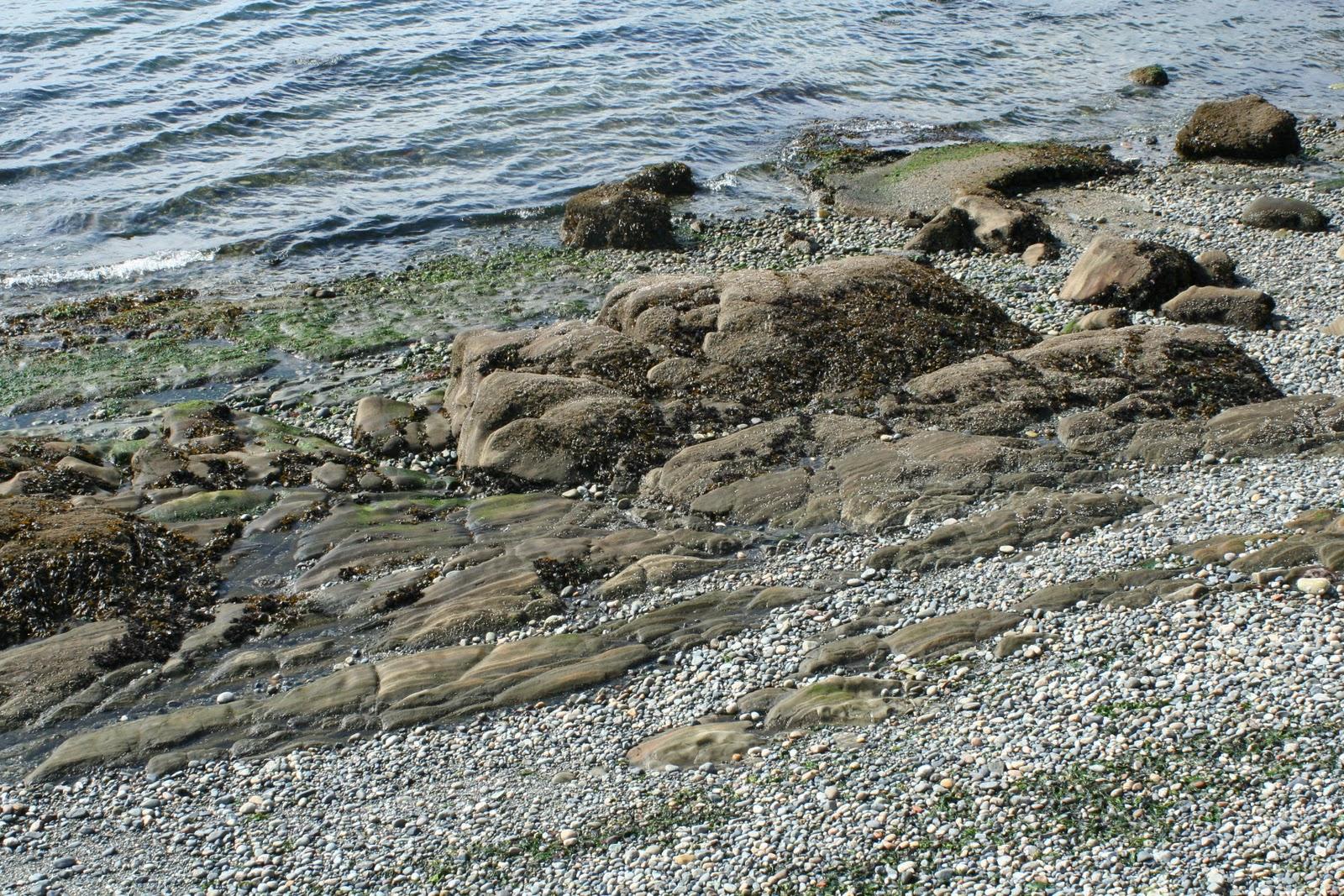
The fossil-bearing bedrock is best viewed at low tide along the southern shoreline of the park. The walking path runs from the main lot south along the shore for about a half mile before turning into a beach access path. Restoration Point itself, the bluff feature immediately east of Fort Ward, is on private land within the South Beach Estates gated community; do not attempt to access it from the water or by trespassing on adjacent property. The public legal view of the Blakeley Formation in this area is from the Fort Ward shoreline; the type section bluffs at Restoration Point are visible from a distance but not accessible.
What Fossils You'll Find
The Blakeley Formation at Fort Ward is the same shallow-marine succession that crops out at Alki Point in West Seattle and as a thinner exposure at Discovery Park further north. The unit at Fort Ward dips locally as steeply as 60° due to movement on the Seattle Fault system, which crosses Rich Passage immediately south of the park; in some shoreline exposures the originally horizontal bedding planes now appear nearly vertical, with weathered fossil shells visible in cross-section in the cliff face.
Marine bivalves and gastropods are the most common fossils. The Pacific Northwest Oligocene mollusk fauna at this stratigraphic level includes Yoldia, Acila, Spisula, Nuculana, turritellid and naticid gastropods, and a variety of others. The most striking fossils are calcareous concretions, weathered out of the bedrock and accumulated as round-to-ovoid lumps on the beach. The Burke Museum's working collection of Blakeley crab concretions is largely sourced from outcrops of this same formation along the Puget Sound shorelines. The shark Echinorhinus blakei, originally named for the Blakeley Formation, is documented from the unit; teeth are rare but recorded. Trace fossils (burrows, escape structures) are common on bedding planes.
Important note: Restoration Point, immediately east of Fort Ward Park, is a wave-cut platform tectonically uplifted about 23 feet during a large earthquake on the Seattle Fault approximately 1,100 years ago. The uplifted bench is part of the late Holocene archaeological record, not the Blakeley Formation. The Blakeley sandstone underlying it is the same unit that crops out at Fort Ward. The visible old shoreline notch on the bluff at Restoration Point is one of the earliest pieces of evidence that the Seattle Fault is seismogenically active.
Geologic History
The Blakeley Formation records the marine shelf history of the proto-Puget Sound region during the late Oligocene to early Miocene, roughly 33 to 25 million years ago. The Cascade Range was rising to the east but had not reached its modern elevation, and the future Puget Lowland was a shallow embayment receiving sand and mud from the eastern highlands and the developing volcanic arc. The Blakeley accumulated as alternations of medium-grained sandstone (with rare conglomerate beds) and finer siltstone in 20 to 100 metres of water on a sandy shelf with abundant marine invertebrate life. Periods of slower sedimentation allowed phosphatic and calcareous concretions to grow around isolated organic nuclei, producing the famous concretion fauna.
The formation was named for Blakely Harbor on Bainbridge Island and is named in the geological literature for outcrops on the south end of the island around Restoration Point. The formation was tilted by movement on the Seattle Fault system, which runs east-west through Rich Passage immediately south of Fort Ward; the steep dips visible in shoreline outcrops record this tilting. Quaternary glaciations scoured the modern shoreline and removed most younger material, leaving the Blakeley bedrock at or just below the modern shoreline.
The 1,100-year-old Seattle Fault earthquake at Restoration Point uplifted the original wave-cut platform by about 23 feet, leaving the Blakeley bedrock of Restoration Point standing as a relict raised shoreline. The same fault movement that uplifted Restoration Point also tilted the broader region; the documented uplift was a major foundation for modern understanding of seismic hazard in Puget Sound.
How Fort Ward became a public fossil window
Fort Ward operated as a U.S. Army coastal-artillery installation from 1903 through World War II. The fort was decommissioned in 1958, transferred to Washington State Parks, and later (in 2011) transferred to Bainbridge Island Metro Park & Recreation District. The shoreline trail and beach access were preserved as part of the park; the surrounding upland Restoration Point area was sold and developed as a gated residential community. The result is that Fort Ward Park's shoreline is now the only public-land access to the Blakeley Formation in this region, while Restoration Point itself — the better-known landmark — is private.
Collecting Rules & Regulations
Is Fossil Collecting Allowed?
No. Fort Ward Park is administered by Bainbridge Island Metro Park & Recreation District as a passive-use park; removing rocks, fossils, or natural materials is prohibited.
Key Points:
- Viewing and photography only. Do not remove any rock, fossil, or shoreline material.
- Visit at low tide for the best bedrock exposure.
- Restoration Point and its bluffs are private and not accessible. Do not attempt to enter from the water or via adjacent properties.
- The Seattle Fault runs through Rich Passage immediately south; the tilted bedding planes record the fault's late Cenozoic activity.
- For collecting at a Blakeley-equivalent locality, no public-access option currently exists; the Burke Museum is the institutional gateway.
Sources
Nearby sites
 Alki Beach Blakeley Formation Fossil Hunting GuideMarine mollusks, Crab concretions
 Chuckanut Drive & Larrabee State Park Fossil Hunting GuideFossil palm fronds (Sabalites), Fossil leaves
 Racehorse Creek Chuckanut Fossil Fields Hunting GuideFossil palm fronds (Sabalites), Tree fern fronds (Cyathea pinnata)
 Ginkgo Petrified Forest State Park Fossil Hunting GuidePetrified wood (Ginkgo), Petrified wood (50+ species)