Centerville Beach Fossil Hunting Guide
Centerville Beach near Ferndale in Humboldt County, California exposes the Rio Dell Formation, a Plio-Pleistocene marine mudstone. Shell fossils including Giant Pacific Scallop, moon snail, cockle, and dogwinkle protrude from gray clay cliffs along the south end of the beach. Visit at low tide only.
Centerville Beach is a long, windswept stretch of sand about five miles west of the Victorian town of Ferndale in Humboldt County, California. The cliffs behind the south end of the beach expose the Rio Dell Formation, a Plio-Pleistocene marine mudstone deposited roughly 1 to 3 million years ago on the edge of a shallow sea. Shell fossils protrude directly from the gray clay cliff face, and loose specimens wash out onto the beach below after storms and high tides. The site produces well-preserved bivalves and gastropods from at least ten identifiable genera. It is a county beach with free access and no entrance fee.
Location and Directions
Centerville Beach County Park is on Centerville Road, Ferndale, California 95536. It sits on the Lost Coast of northern California, between the Eel River mouth to the north and Cape Mendocino to the south.
From Highway 101 south of Eureka, take the Ferndale exit. Cross the Fernbridge and drive about five miles west into Ferndale. At the south end of Main Street, turn right onto Ocean Avenue. This road becomes Centerville Road. Follow it about five miles until the road meets the ocean and turns south. The parking area is right behind the beach.
The closest commercial airport is Arcata-Eureka Airport (California Redwood Coast Airport), about 30 miles north. Eureka has fuel, food, and lodging. Ferndale itself has restaurants, a general store, and a few inns, but no gas station. Cell coverage is weak along the coast, so download maps before leaving Highway 101.
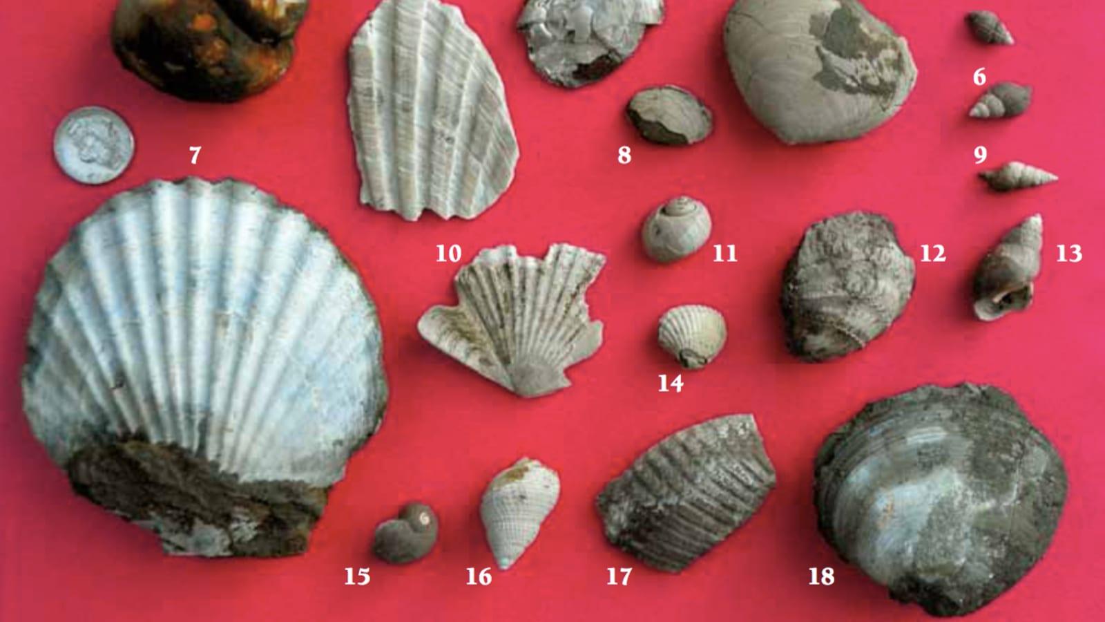
What Fossils You Will Find
The fossils at Centerville Beach are Plio-Pleistocene marine invertebrates, predominantly bivalves and gastropods that lived in a shallow coastal environment similar to today's northern California shelf. The following species have been identified from the site, documented by Leslie Scopes Anderson in the Cal Poly Humboldt fossil guide and by Ellin Beltz in her Humboldt County locality descriptions.
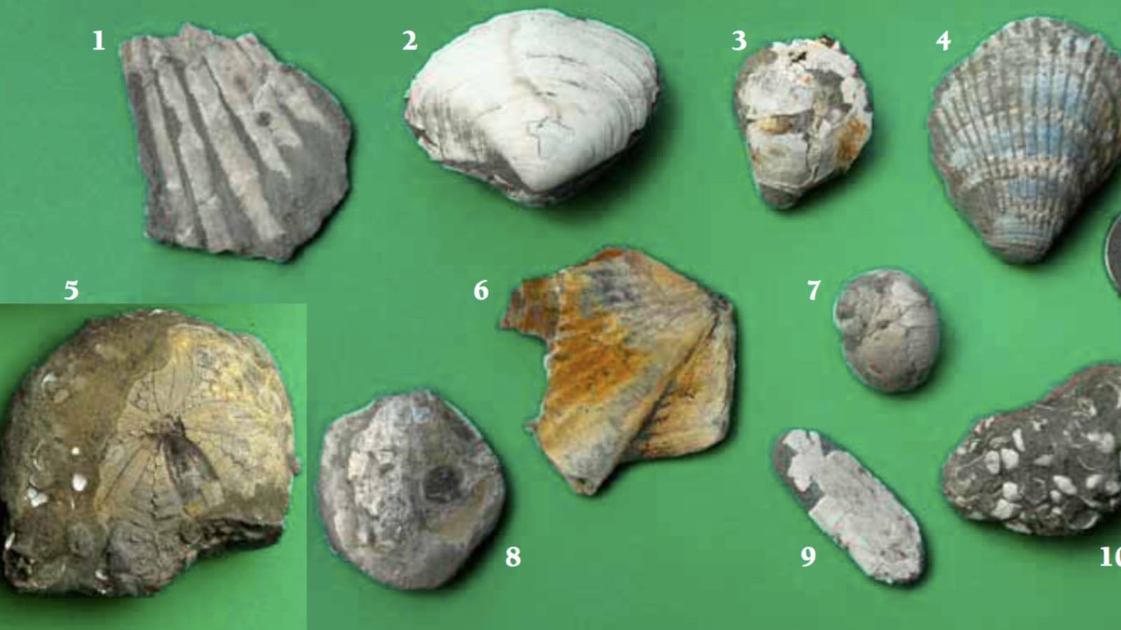
Patinopecten sp. (Giant Pacific Scallop) is the most prominent fossil at this site. Specimens can reach up to 15 cm across and are often found as complete, well-preserved valves in the mudstone. They appear as raised or slightly recessed circular outlines in the cliff face.
Natica clausa (Moon Snail) turns up frequently as small, rounded shells in the gray mud. Clinocardium meekianum (Cockle) appears as ribbed, heart-shaped valves, sometimes still articulated. Nucella canaliculata (Channeled Dogwinkle) is a smaller gastropod recognizable by its channeled suture line.
Other recorded species include Pandora sp. (a thin, flat bivalve), Antiplanes sp. (a slender, turreted gastropod), Macoma sp. (a thin-shelled clam), Tellina modesta (Modest Tellin), Cyclocardia sp. (Cardita), and Nassarius sp. (Nassa shell). Most of these are direct ancestors or close relatives of species still living along the northern California coast today.
At the broader formation level, the Rio Dell Formation has also yielded vertebrate fossils from other localities. An early Pleistocene gray whale (Eschrichtius) was described from the formation in Humboldt County, and fossils of the fur seal Callorhinus have been reported from the uppermost Pliocene to lower Pleistocene sections.
Geology
The Rio Dell Formation is part of the Wildcat Group, a thick sequence of Pliocene to Pleistocene marine and nearshore sediments exposed along the coast and river bluffs of Humboldt County. Piper (1976) described the Rio Dell Formation as a prograded sequence of basinal turbidites overlain by basin slope and shelf deposits. The slope deposits accumulated in a steadily shallowing environment, with benthic foraminifera indicating deposition at depths ranging from roughly 1,000 down to 100 meters as the basin filled.
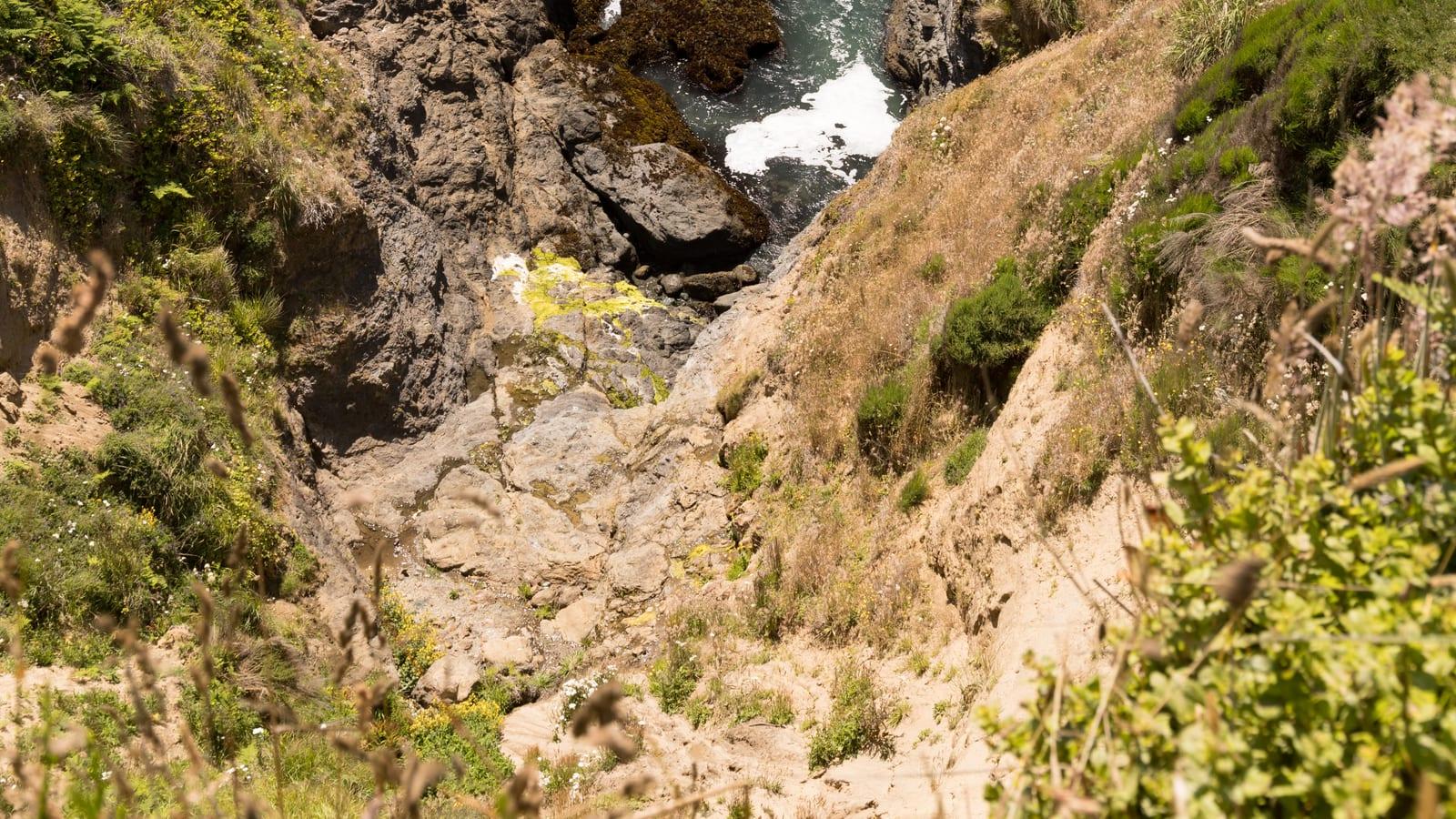
At Centerville Beach, the exposed section consists of poorly consolidated gray mudstone and siltstone with occasional lenses of sandstone and conglomerate. According to the stratigraphic column published by Anderson (2011), the Rio Dell Formation at this location underlies the Scotia Bluffs Sandstone and sits above the Eel River Formation. The fossils are concentrated in the mudstone layers, where the fine-grained matrix preserved shells with minimal crushing.
The cliffs at Centerville Beach have the highest erosion rate of any coastal site in California. A 2022 study reported by the Lost Coast Outpost found that the bluffs are retreating faster than at any other monitored location in the state. This rapid erosion constantly exposes fresh fossil-bearing mudstone, which is why loose specimens are regularly found at the base of the cliffs and on the beach surface after winter storms.
The tectonic context drives this erosion. The coastline sits near the Cascadia Subduction Zone, where the Gorda Plate dives beneath the North American Plate. Ongoing tectonic uplift has raised the former seafloor sediments to cliff height, while the combination of heavy rainfall, large waves, and seismic activity keeps the bluffs crumbling.
Access Rules and Fees
Centerville Beach County Park is managed by Humboldt County. There is no entrance fee and no parking fee. The beach is open year-round with no seasonal closures.
The site is a public beach, not a protected geological reserve. Casual collecting of loose fossils from the beach surface and cliff face is generally practiced by visitors and local geology students. The Cal Poly Humboldt fossil guide advises collectors to "leave specimens for future explorers," reflecting a conservation ethic rather than a legal prohibition. If you collect, take only what you can identify and study, and leave material in place for others.
Dogs are allowed off leash on the beach. Horses are permitted. Fires are allowed, but camping is not. Vehicles with four-wheel drive can access the beach, but two-wheel-drive vehicles risk getting stuck in the sand.
Where to Look
From the parking area, walk south along the beach. The first section of cliff is golden-brown sandstone from the overlying Scotia Bluffs Sandstone. Continue south for about half a mile until the cliff face transitions to gray, poorly consolidated mudstone. This is the Rio Dell Formation, and it is the fossil-bearing layer.
Look closely at the mud cliff face. Scallop shells, cockles, and snail shells protrude from the surface, sometimes just the edge of a valve, sometimes a nearly complete specimen. Fossils also wash out of the cliff and collect at the base. After storms or high tides, fresh material appears on the beach surface below the cliffs.
The fossiliferous exposures continue almost to the mouth of Fleener Creek. Beyond Fleener Creek, the beach becomes too narrow to walk safely except at very low tides. You can also reach the fossil cliffs from a second access point at the Fleener Creek trailhead, farther south along Centerville Road. From there, the trail descends steeply to the beach, and you walk north along the mud cliffs.
A round trip from the main parking lot to the fossil beds and back covers about two miles and takes roughly two to three hours, depending on how long you spend at the exposures.
Hazards
The cliffs at Centerville Beach are unstable and actively eroding. Do not stand directly beneath overhanging sections of mudstone, and do not climb the cliff face. Sections can collapse without warning, especially after rain. Keep a body-length distance from the cliff base when walking.
Tides are the most serious safety concern. The beach narrows considerably toward the south end, and a rising tide can trap you against the cliffs with no escape route. Check the NOAA tide tables for Humboldt Bay before your trip. Go only during a falling or low tide, and begin walking back well before the tide turns.
Winter storms bring large waves that can reach high up the beach with little warning. The surf along this stretch of coast is powerful and the water is cold, typically 48 to 54 degrees Fahrenheit. Do not turn your back on the ocean.
The area receives heavy rainfall from October through April. The clay underfoot becomes extremely slippery when wet, and the trail down to Fleener Creek can be treacherous in the rain. Wear boots with good traction.
A large white cross stands on the bluff at the south end of the beach. This California Historical Landmark (No. 173) marks the site of the SS Northerner wreck of January 6, 1860, a reminder that this coast is exposed and unforgiving.
Sources
- Leslie Scopes Anderson, "A Beginner's Fossil Guide to the Northern California Coast," Humboldt State University (2011). https://natmus.humboldt.edu/sites/default/files/geol-fossil-guide.pdf
- Ellin Beltz, "Fossil Localities, Humboldt Bay Area" (2008). http://ebeltz.net/fieldtrips/humfossils.html
- California Beaches, "Centerville Beach County Park." https://www.californiabeaches.com/beach/centerville-beach-county-park/
- D. J. W. Piper, "The Rio Dell Formation: a Plio-Pleistocene basin slope deposit in Northern California," Sedimentology 23 (1976). https://onlinelibrary.wiley.com/doi/10.1111/j.1365-3091.1976.tb00052.x
- Lost Coast Outpost, "Centerville Beach Has a Higher Rate of Cliff Collapse Than Anywhere Else on the California Coast, Study Finds" (2022). https://lostcoastoutpost.com/2022/aug/18/centerville-beach-has-higher-rate-cliff-collapse-a/